


Luzerne County’s Flood Protection Authority held a special meeting Thursday to unanimously approve the first step in fixing erosion that is creeping toward part of the Wyoming Valley Levee system flood wall along Riverside Drive in Wilkes-Barre.
Verdantas LLC in Plains Township will be paid $24,670 to survey both the land and the Susquehanna River at that location. This will include the use of lidar (light detection and ranging) technology, in which variations in light pulses between the surface and a drone are measured to precisely map out the topography.
Authority Chairman Dominic Yannuzzi, an engineer, said surveying is necessary to assess the cause and determine if further data, such as core borings, must be obtained to identify the solution. Survey results also must be compared to historical geotechnical data to see how conditions at the site have changed over time, he said.
Yannuzzi and his fellow board members — Wilkes-Barre Fire Chief Jay Delaney, Vice Chairman William Hardwick, Coray Mitchell and John Maday — discussed their continued commitment to swiftly address the matter Thursday.
“It’s a priority. We’ll just keep moving this forward as fast as we can,” Yannuzzi said.
The matter came to light at last week’s authority meeting, prompting the special meeting to bring in an outside engineering contractor.
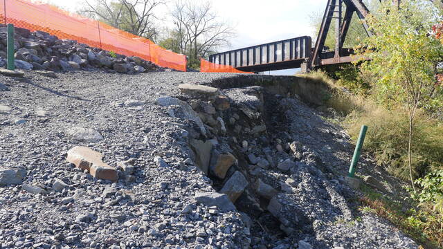
Authority Executive Director Christopher Belleman had said levee workers discovered the river embankment “sloughing” in July while addressing a downed tree nearby. On slopes, slough is soil, rock and debris that has moved downhill, according to the U.S. Department of Agriculture.
The spot of concern is near the intersection of Riverside Drive and Academy Street by the Black Diamond railroad bridge. This section has been stable for decades, but started to slough in recent months, Belleman had said.
Belleman has been monitoring the erosion since mid-July and observed it is “progressively getting closer to the flood wall.” He emphasized that the flood wall is not threatened at this time, but could be in the future if the situation continues.
Delaney said Thursday the Verdantas contract honors the authority’s quest for prompt action by requiring surveying crews to be on site within five days of the notice to proceed and complete a report within two weeks of the surveying completion. Yannuzzi said the survey should take about two days.
Authority members agreed to act on the findings at their next meeting Nov. 18 or possibly schedule another special meeting if additional time is needed.
Maday asked if a similar situation could be occurring elsewhere, and Belleman said he is not aware of any other sloughing along the 16-mile flood control system.
Belleman said there may be a large “scour,” or hole, developing in the river near the Black Diamond Bridge, and surveying is needed to see below water.
Yannuzzi pointed to the spot on a wall map in the meeting room to show it coincides with a curve in the river. He said the river “wants to continue to go straight” and must hit the bank to continue flowing through the curved section, which can cause erosion.
Belleman said velocity increases when water is restricted, causing erosion.
Maday said the river curve is “very dramatic” and said there were issues with the levee in that vicinity during the 1972 Agnes Flood due to “all that pressure.”
Hardwick questioned how the authority will respond if the river significantly rises before a solution is finalized and implemented.
Yannuzzi said the authority receives notice several days before high-water events and would have “time to react” following an emergency action plan. He has said large stones could be placed at the site for stabilization.
Belleman reiterated that the concrete flood wall covers an interlocked steel sheet pile that provides the primary flood protection. This sheet pile is driven 40 feet into the ground.
For added reassurance, Belleman said he and authority Deputy Executive Director Laura Holbrook also check National Weather Service forecasts and other river monitoring data daily.
“It’s just part of what we do,” he said.
He has estimated a permanent fix could cost $500,000. The authority was informed no federal funding is available for such a project, but Belleman said the surveying data may document damage that qualifies the project for federal assistance.